Volunteers Needed! Contact Joe Flamini W4BXG.
Joe Flamini W4BXG wrote:
Hi, All—
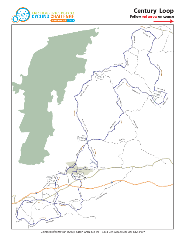
The Boys & Girls Club Race is in two weeks (Sunday, 15 September), and we need a few conscripts. I’m actually gonna be a part of this one, so I need six more souls. Only two of the posts are all day; the other five are only partials.Here are the seven posts:Old Trail Swim Club (HQ)– 7:00 on (All day)
White Hall Community Center– 7:00 on (All day)
Greenwood Community Center– 8:00-12 Noon
Broadus Wood School– 11:00- 4:00
Boonesville– 10:00-2:30
1 SAG– 8:00-11:00
1 SAG– 11:00-4:00
They’ll provide rides for SAGs; I’ve got club event radios as before.I’ll send the map in an e-mail immediately following this one.
Race Sites
The website for the event is: http://www.bgcchallenge.org/
Facebook
twitter
Email List
Map Pages
GPS tracks:
- 100 miler: http://ridewithgps.com/routes/2778899
- 75 miler: http://ridewithgps.com/routes/2855410
- 55 miler: http://ridewithgps.com/routes/2855409
- 28 miler: http://ridewithgps.com/routes/2855407
- These were posted by one of the race organizers in 2013 so should be good.
Download Script
If you have wget installed on your machine, use the following script to download files relevent to this race. If you have wkhtmltopdf (Free: Linux, Mac OS X, Windows) it will also take snapshots of some web pages.
wget http://www.bgcchallenge.org/userfiles/image/flyer-2013.jpg
wget -O BGCCC_2013_100mile_track.gpx http://ridewithgps.com/routes/2778899.gpx?sub_format=track
wget -O BGCCC_2013_100mile_route.gpx http://ridewithgps.com/routes/2778899.gpx?sub_format=route
wget -O BGCCC_2013_100mile.kml http://ridewithgps.com/routes/2778899.kml
wget -O BGCCC_2013_100mile.csv http://ridewithgps.com/routes/2778899.csv
wget -O BGCCC_2013_100mile_lowres_map.png
wget -O BGCCC_2013_75mile_track.gpx http://ridewithgps.com/routes/2855410.gpx?sub_format=track
wget -O BGCCC_2013_75mile_route.gpx http://ridewithgps.com/routes/2855410.gpx?sub_format=route
wget -O BGCCC_2013_75mile.kml http://ridewithgps.com/routes/2855410.kml
wget -O BGCCC_2013_75mile.csv http://ridewithgps.com/routes/2855410.csv
wget -O BGCCC_2013_55mile_track.gpx http://ridewithgps.com/routes/2855409.gpx?sub_format=track
wget -O BGCCC_2013_55mile_route.gpx http://ridewithgps.com/routes/2855409.gpx?sub_format=route
wget -O BGCCC_2013_55mile.kml http://ridewithgps.com/routes/2855409.kml
wget -O BGCCC_2013_55mile.csv http://ridewithgps.com/routes/2855409.csv
wget -O BGCCC_2013_28mile_track.gpx http://ridewithgps.com/routes/2855407.gpx?sub_format=track
wget -O BGCCC_2013_28mile_route.gpx http://ridewithgps.com/routes/2855407.gpx?sub_format=route
wget -O BGCCC_2013_28mile.kml http://ridewithgps.com/routes/2855407.kml
wget -O BGCCC_2013_28mile.csv http://ridewithgps.com/routes/2855407.csv
wget -O BGCCC_2013_100mile_lowres_map.png http://ridewithgps.com/ruter/2778899/full.png
wget -O BGCCC_2013_75mile_lowres_map.png http://ridewithgps.com/ruter/2855410/full.png
wget -O BGCCC_2013_55mile_lowres_map.png http://ridewithgps.com/ruter/2855409/full.png
wget -O BGCCC_2013_28mile_lowres_map.png http://ridewithgps.com/ruter/2855407/full.png
wget https://www.albemarleradio.org/sites/default/files/bgccc_2013_propagation_760_895_925.jpg
wget https://www.albemarleradio.org/sites/default/files/BGC_25mile.pdf
wget https://www.albemarleradio.org/sites/default/files/BGC_50mile.pdf
wget https://www.albemarleradio.org/sites/default/files/BGC_75mile.pdf
wget https://www.albemarleradio.org/sites/default/files/BGC_100mile.pdf
wget https://www.albemarleradio.org/sites/default/files/BGCCC_2013_prop_path.pdf
wget https://www.albemarleradio.org/sites/default/files/bgccc_2013_propagation_760_895_925.jpg

wkhtmltopdf https://www.albemarleradio.org/node/163/ AARC_bgccc_2013_event_page.pdf
wkhtmltopdf http://www.bgcchallenge.org/event-description/event-description bgccc_2013_event_description.pdf
wkhtmltopdf http://www.bgcchallenge.org/ bgccc_2013_main_page.pdf
Related software:
- wget: free open source cross platform command line based file download utility
- gpsbabel: free open source cross platform command line based GPS format conversion utility
- Google Earth: free but proprietary closed source cross platform world viewer application
- KDE marble: free opens source cross platform world viewer application. Not as full featured as google earth yet but it does have APRS and satellite tracking plugins built in and has the ability to download regions for offfline use.
- google maps: free web based map software. Versions exist for smartfones/tablets but will be limited to areas with WiFi/cell phone reception. Paste kml url into search box on web based version.
- wkhtmltopdf Command line utility to grab snapshots of webpages as pdf files. Free, open-source, cross-platform: Linux, Mac OS X, Windows)
- Xastir APRS software. Free of charge, open-source, cross-platform. A bit of a learning curve.
- Adobe Acrobat Reader. PDF Reader. The only one which can currently handle geopdf maps. Free of charge, proprietary closed-source, cross-platform: Linux, Mac OS X, windoze.
Propagation Maps
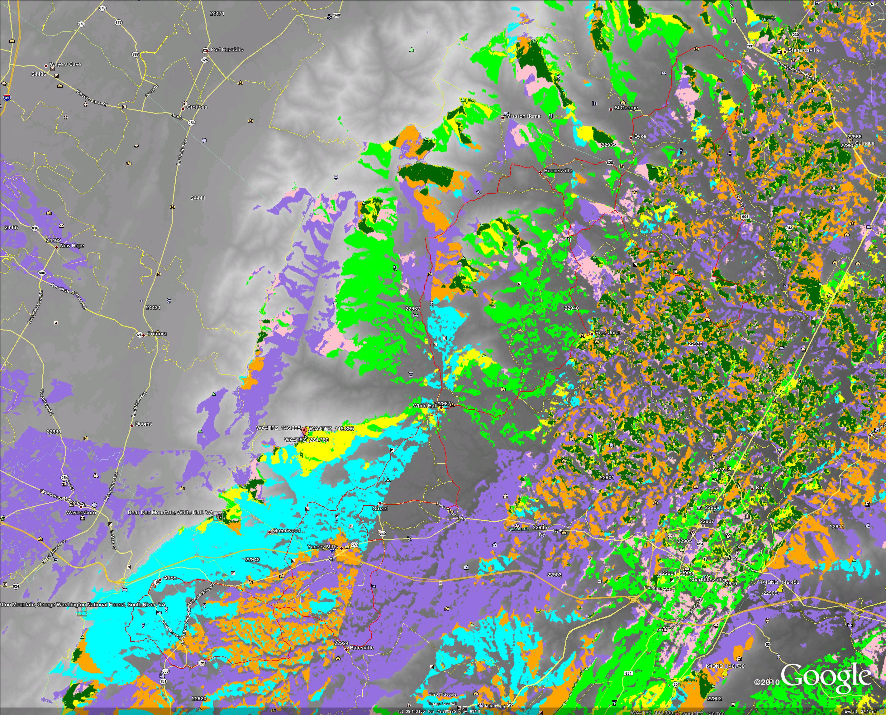
I wrote a program to plot signal strength along a path. Here is the propagation along the 100mile route:
Ride routes and Member QTHs
BGCCC routes with member QTHs superimposed .KML file to load in Google Earth, KDE marble, etc. Also view in Google Maps and Google maps, prezoomed (members outside country through things off a bit otherwise). And Embeded.
Geocoding: Texas A&M Geoservices Services
To add the KML file to google earth, there are several ways:
- Click link and select open. If googleearth is already running on your computer, don’t try to open the link. This has been known to start a second copy of google earth that does not play well with the first and may corrupt your places file.
- save the file to disk and then choose File -> Open. Using this method, you can import all of the downloaded KML files at once. They will end up under “Temprary Places” and you need to drag and drop to “My Places” if you want them there next time you run google earth. Google will make a duplicate copy inside myplaces and you can change without affecting original file. This bloats your myplaces file a bit.
- Under the “Places” section of the left sidebar, right click on My Places and “Add Network link” and enter the URL. This will fetch the file off network when needed. May not be available offline. In theory, we can update the file on the server and the changes will propagate to you but I haven’t looked at the polling interval. More network traffic, slower. Might be cached.
- Under the “Places” section of the left sidebar, right click on My Places and “Add Network link” and browse to a file you have already saved on disk. This will probably not make a duplicate copy inside your myplaces file but use the disk where it sits.
Inside google earth, if you right click on the 100mile route (or the other routes) in the Places portion of the left sidebar, you can select “view elevation profile”.
Communications Plan
TBD.
This race is difficult to cover even with 3 repeaters.Originally published: Tue, 09/03/2013 – 08:27 — ak4ol. Date altered to affect sticky list ordering.


